close
Epic Treks of the Andes and Amazon
-
filterDay 1 : Waking Time: 5 hours Distance: 11 km ...Waking Time: 5 hours Distance: 11 km Accommodations: Historic Hacienda Hotel Pinsaquí Drive north from Quito towards the equatorial line monument and continue towards the Pululahua Volcano whose crater is crossed by Latitude 0°. This crater is a geo-botanical reserve where diverse environments are found, including a montane cloud forest, a myrtle forest and a dry acacia forest. This reserve is home to a large diversity of birds including hummingbirds, mountain tanagers, eagles and hawks. Begin the trek through an arid flux of sulfur deposits and amongst a dry forest. As we gradually gain altitude this path turns into a lush primary cloud forest where we find abundant myrtles and very good birdlife. Once the top of the old crater rim is reached, lunch will be served at an archeological site located at a neighboring private hacienda. This archaeological platform is a solar calendar built 2000 years ago by the pre-Inca indigenous people known as the Yumbos which means Toucan Barbet. The guide will explain how this remarkable people marked the equator line with impressive accuracy and how they used this calendar to plan their agricultural cycles. Continue walking on a trail east of the Pululahua volcano with breathtaking views of the valleys beneath us. Overnight at the beautiful historic hacienda Pinsaquí. (L D)
-
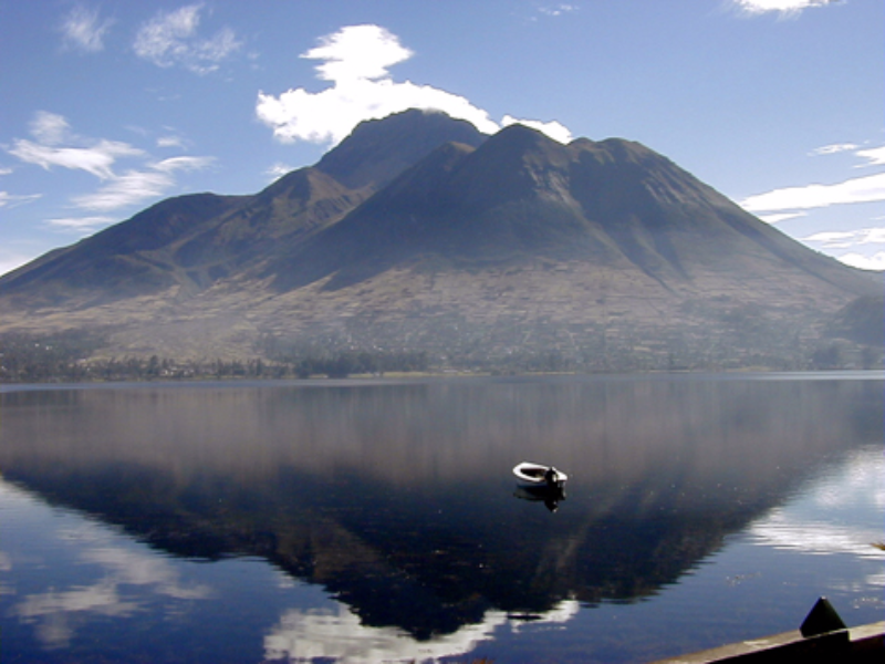
filterDay 2 :Walking Time: 4 hours Distance: 10km ...Walking Time: 4 hours Distance: 10km Accommodation: Historic Hacienda Hotel Pinsaqui Early in the morning drive to nearby Cuicocha Crater Lake which, at 3,070 meters, is a nature reserve located on the slopes of the larger Cotacachi Volcano. Cuicocha Lake is surrounded by rim walls and its name translates as Lake of the Guinea Pigs due to the shape of its two center islets. This ecosystem is a combination of paramo and Andean forest where we find species such as Pumamaqui, Quishuar, chilca, bromarea, fushia, lupins, calcelaria, and colorful flowers of the Andes. This hike known as the Trail of the Orchids runs around the crater rim with stunning views to the lake and the Cotacachi, Mojanda and Imbabura volcanoes. We will be watching for rodents, mammals, marsupials and birdlife such as guans, hummingbirds, tanagers, wild turkeys, ducks, buzzard eagle and the great Andean Condor. A healthy and appetizing picnic lunch will be served along the trail. In the afternoon we will have some time to visit the town of Cotacachi and its leather market. We will also visit the Otavalo Indian Market, one of Ecuador's most important indigenous bazaars filled with handmade arts, clothes, tapestries, jewelry, ceramics and wood carvings. Overnight in Hacienda Pinsaqui (B L D)
-
filterDay 3 : Walking Time: 4 hours Distance: 10.6 ...Walking Time: 4 hours Distance: 10.6 km Accommodation: Papallacta Hotsprings Resort Early morning drive through the Inter-Andean valleys and gain elevation through a stunning canyon to reach the Atlantic - Pacific continental divide at 4,100 meters. Begin the hike through the Cayambe-Coca Reserve that offers some of the best scenery in the country. This reserve is part of a larger United Nations Biosphere Reserve that encompasses two other national reserves. The environment here is endemic highland paramo (moorlands) with patches of cloud forest. This area of the Andes retains great amounts of water as it is the source to the largest water system in the world. It features a great number of lakes, possibly the highest concentrations in the Andean range. Walk mostly downhill towards the Amazon side, seeking out three different species of dear, the elusive spectacled bear and birdlife including the Andean Condor. End this hike in the Papallacta hot springs to enjoy the medicinal and mineral-rich thermal waters. The spa service is highly recommended. We spend the evening at the Papallacta Resort. (B L D) Continental Divide Hike
-
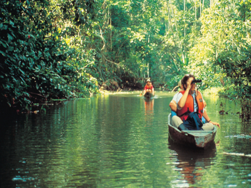
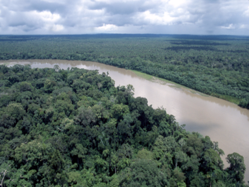
filterDay 4 : Walking Time: 7.5 hours Distance: 12 ...Walking Time: 7.5 hours Distance: 12 kilometers Accommodation: Cotococha Jungle Lodge After breakfast drive through a scenic road that descends further into the Amazon basin through the Papallacta river gorge. Reach the Sumaco National Park a large tropical area that features the Sumaco Volcano which is one of the few active volcanoes that arise from the Amazon Basin. Arrive to the Guacamayos (Macaw) range at 2200 meters with spectacular views to the Amazon flatlands below. The environment here is a montane cloudforest where many species from the jungle and the highlands coexist, as well as many species that only live here. There is a great opportunity to see the cock-of-the-rock, toucans, caciques, oropendolas, manakins, military macaws and many other species. Walk through a spectacular trail enjoying the many sounds of nature and appreciate the transition from cloud forest to rainforest at the end of the trail. It can get a bit muddy, as this trail includes several stream crossings following down to the swamplands of the blue Urcusiqui River. A delicious and healthy picnic lunch will be served along this hike. In the afternoon continue by vehicle to visit an indigenous Kichwa family that lives in the town of Archidona. Opportunity to interact and learn about the jungle life through the Waira Churis (Wind Dancers). Continue to our river front jungle lodge for a well deserved rest amidst jungle sounds. (B L D)
-
filterDay 5 : Walking Time: 2 hours Distance: 3 kil ...Walking Time: 2 hours Distance: 3 kilometers Accommodation: Hacienda Manteles This day involves less walking and more time to enjoy and recover at a lower altitude. After breakfast at our riverfront jungle lodge a walk in the nearby reserve at the 500 meter level, in search for species specific to the tropical lowland rainforest. Explore --under a 40-meter canopy-- for trees such as balsa, cedar, rubber, kapok and cinnamon, as well as many bromeliads, orchids, vines, ferns, insects and reptiles. This area has a long history of indigenous cultures and is the opportunity to learn about the traditional use of plants for daily living and medicinal purposes. Visit a local Kichwa community to learn about their way of life, culture, traditions, and customs. After lunch head south and climb back up the Andes through the Pastaza River Gorge, one of the principal waterways that feed into the Amazon Basin. This is an especially scenic route, with high rock walls giving way to deep cloud forest canyons. Stop to admire some of the spectacular waterfalls in the area, such as Pailón del Diablo (Devil's Cauldron) and Manto de la Novia (Bride's Veil). Continue on to Baños de Agua Santa a quaint colorful subtropical town on the slopes of the erupting Tungurahua volcano; get some fantastic views of the Tungurahua before arriving to Hacienda Manteles. (B L D)
-
filterDay 6 : Walking time: 4 to 5 hours Distance: ...Walking time: 4 to 5 hours Distance: 10.7km Accommodation: Historic Hacienda La Cienega The Llanganates is considered one of the world's most mystical mountain ranges. Perhaps this is due to those who have gone there and never returned; to stories of failing compasses or the legend that Atahualpa (the last Inca Emperor) decided to hide the world's most impressive Inca treasure here. The Llanganati as it is known by the locals means Beautiful Mount and is a vast 200,000-hectare reserve on the eastern Andes with altitudes that fluctuate between 4,500 and 1,200 meters. Hike at about 3,500 meters in a combination of cloud forest, Andean forest and paramo. This trail offers a great variety of birds and animals including hard-to-see species such as the spectacled bear --likely to be found at Laguna San Borja in the early morning. During this day there are great views of the surrounding volcanoes and many species of hummingbirds, mountain tanagers and deer can be seen. At the end of the trek descend into the Patate Valley through the ancient Panzaleo Trail. Overnight at La Cienega, a hacienda with 300 years of history. (B L D)
-
filterDay 7 :Departure ...Departure Date.